


Ask ten hikers about the “best” routes in the Austrian Alps and you will probably get ten different answers. What follows is not a ranking pulled from brochures, but a comparison of routes I have actually walked, often more than once, across several regions of Austria. All of them are hikes I would genuinely repeat, and together they show how different the Austrian Alps can feel from valley walk to glacier balcony.
How This Comparison Works
Austria’s tourism offices love big names like the Zillertal Alps, Hohe Tauern and Ötztal Alps, and the summer lift networks in Tirol and Vorarlberg certainly make high-level hiking more accessible. But as a hiker you experience these regions one trail at a time. This comparison focuses on individual day hikes that I have personally completed, using them as concrete examples of what you can expect from valley walks, panoramic balcony paths, lake hikes and genuine non-technical summits.
For each hike I include approximate distance, actual walking time from my own trips, ascent and descent, maximum altitude where available, trail surface and exposure, technical difficulty, crowd levels, and how I reached the start by car or public transport. I also flag where cable cars are involved, because that often makes the difference between a relaxed day and an exhausting one. Importantly, I distinguish hiking from technical mountaineering. None of the routes below requires ropes or glacier gear in standard summer conditions, and where terrain starts to flirt with mountaineering territory, I say so clearly.
Distances and elevation figures are drawn from a mix of official sources, local information boards and GPS tracks, then rounded to keep expectations realistic instead of overly precise. Weather, snowfields, heat and rapid afternoon thunderstorms all influence how hard a route feels, and those realities are as important as any number on a signpost. If official difficulty ratings did not match my experience on a particular day, I explain why.
The result is not a Tirol-only checklist, nor a collection of extreme objectives. It is a practical short list of Austrian hikes I would happily repeat and recommend to reasonably fit walkers, along with enough detail to help you decide which ones belong on your own itinerary.
Classic Hut Approach in the Zillertal Alps: Breitlahner to Berliner Hütte
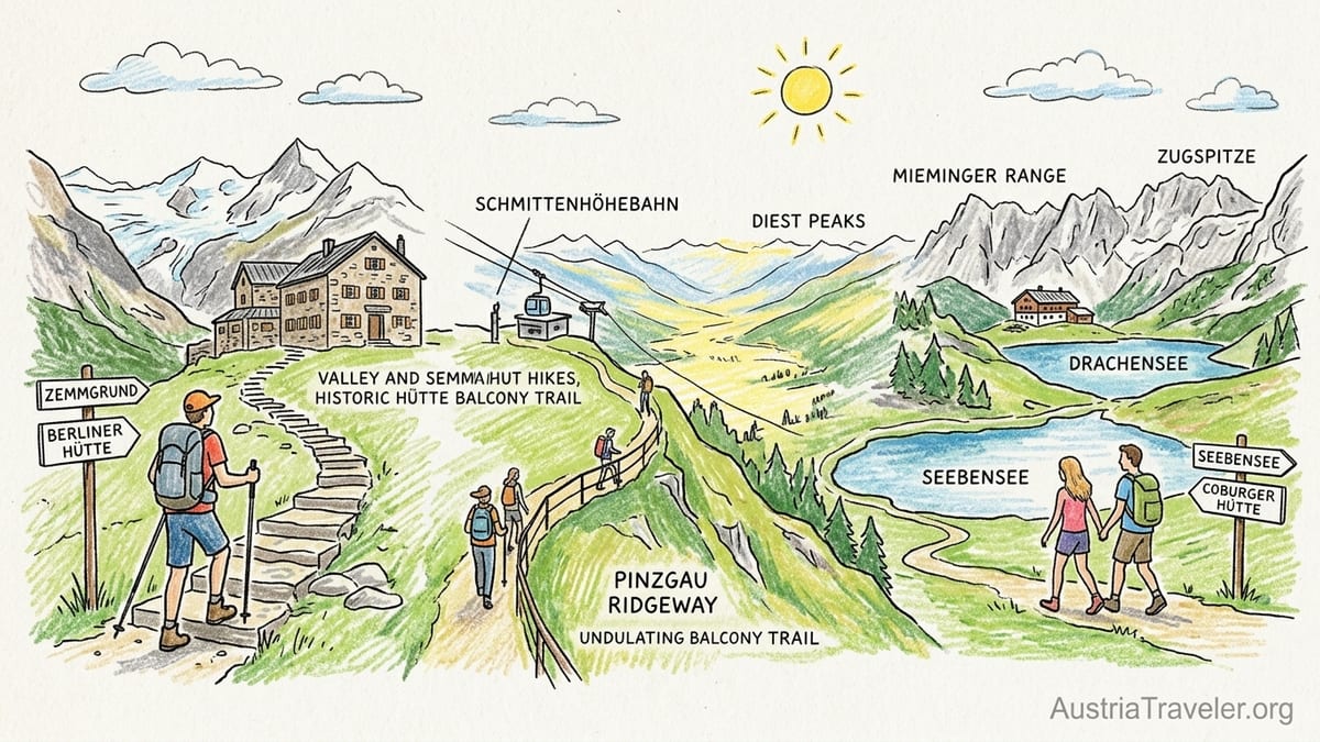
If you want a first taste of the high Zillertal Alps without committing to the full Berliner Höhenweg, the walk from Gasthaus Breitlahner to the historic Berliner Hütte is an ideal introduction. The route lies in Tirol’s Zillertal Alps Nature Park and forms part of a much longer glacier-themed educational trail. From the roadhead at Breitlahner, around 1,250 metres, the path follows the upper Zemmgrund valley to the hut at roughly 2,040 metres. The out-and-back hike is about 14 kilometres in total with 800 metres of ascent, and has taken me around 5 hours of steady walking time, excluding a relaxed lunch in the panelled dining hall of the hut.
The trail begins on a broad forest and farm track along the valley floor, then gradually narrows into a traditional mountain path with stone steps, compacted soil and some rockier stretches. There is no technical climbing, but in wet conditions some boulder sections can be slick. Exposure is low for most of the route because you are walking up a glacial valley, though short traverses above the river feel airy to people unused to mountain paths. Official signposts treat the approach as a “red” mountain hike rather than an easy blue path, which feels appropriate. With a full daypack and in warm weather, the final climb up to the hut can feel tougher than the map suggests.
Weather and water are usually forgiving here. The valley channel funnels clouds, so conditions can change quickly, but you are rarely on a crest where lightning feels uncomfortably close. Snowfields linger early in the season, especially in June, but by high summer the path is usually clear. Streams cross the route regularly, and there are several signed drinking water points before you reach Berliner Hütte, which itself offers meals and basic accommodation. On one hot July visit, I refilled water three times on the ascent and was grateful for the abundant shade in the lower valley. In September the same route felt cooler and more stable underfoot, but afternoons shortened rapidly and the hut was already preparing to close for the season.
Access is straightforward by car via Mayrhofen and the Zemmgrund toll road to Breitlahner, where there is paid parking. Reaching the start by public transport normally involves a bus from Mayrhofen to Ginzling and a seasonal connection deeper into the valley, so check current timetables before you plan an early start. Crowd levels are moderate to high in August because the Berliner Hütte is one of Austria’s most famous refuges, yet the length of the approach spreads people out. In my experience it never felt like a congested promenade, more a steady flow of families, hut-to-hut trekkers and the occasional trail runner, all bound for the same imposing stone lodge at the head of the valley.
A Panoramic Balcony Above the Salzach: The Pinzgau Ridgeway
For a contrasting experience in the Kitzbühel Alps, the Pinzgau Ridgeway between Schmittenhöhe above Zell am See and the lifts at Saalbach-Hinterglemm is one of the most rewarding panoramic high-level trails in Austria that you can still manage as a long day walk. Using cable cars at both ends, the core route along the grassy ridge covers roughly 17 to 20 kilometres with about 750 to 900 metres of ascent and considerably more descent, depending on your exact start and finish. My own traverses have taken between 6 and 7.5 hours of walking time, not counting a hut stop for soup and a Radler.
The character here is open, undulating ridgeline rather than rugged rock. From the top station of the Schmittenhöhebahn at around 1,965 metres, the trail follows a series of broad, sometimes surprisingly quiet crests dotted with ski infrastructure. Underfoot you mostly find compacted dirt and short grass, with occasional stonier patches and wooden boardwalks in wetter sections. There are no hands-on scrambling moves and exposure is modest, although in fog the scale of the terrain and the number of ski tracks crossing the ridge can be disorienting. Official information often describes the route as a medium-difficulty mountain hike. For anyone comfortable with a full day on the move, that feels accurate, but the distance and cumulative elevation hit hard if you are only used to short valley strolls.
Weather is the decisive factor here. On a clear July or early September day, the Pinzgau Ridgeway offers constant views over the Hohe Tauern, including glacier-clad giants around Grossglockner and the Venediger Group. On one August traverse, however, a promising blue morning slid into cold cloud by midday, with wind strong enough to require gloves and a hasty extra layer. There is little natural shelter along the ridge, and thunderstorms build rapidly on hot days, so I now treat this as a fair-weather objective and always check the alpine forecast before stepping onto the lift. Water access is limited away from huts. I carry at least 2 litres and plan to top up at mountain restaurants near Schmittenhöhe and the mid-stations around the Saalbach end rather than relying on streams.
In terms of logistics, the appeal of the Pinzgau Ridgeway lies in its lift support. From Zell am See you ride the Schmittenhöhebahn to the ridge and, at the far end, drop into Saalbach-Hinterglemm via one of several gondolas or chairlifts, then return to Zell by bus or in reverse. This setup makes the ridge surprisingly accessible to visitors based in Zell am See, Kaprun or even Salzburg who are willing to start early. Crowd levels fluctuate with lift opening hours and weather. Near the stations the path can feel busy, with families pushing strollers on the first few gentle kilometres, but by mid-route you often share the ridge with only a few other committed hikers. Compared with valley-based walks, it feels like a genuine mountain day without crossing into mountaineering terrain.
Lake Double Act in the Zugspitze Arena: Seebensee and Drachensee
One of the most photographed hikes in Tyrol is the twin-lake route from Ehrwalder Alm to Seebensee and on to Drachensee and the Coburger Hütte. This is a true lake hike in the sense that water defines both the destination and the mood of the day, yet it takes place in steep, rocky terrain that deserves respect. Using the Ehrwalder Almbahn to reach around 1,500 metres, the out-and-back walk to Seebensee and Coburger Hütte above Drachensee is roughly 12 to 14 kilometres with 700 to 900 metres of ascent, depending on your variant. It has taken me just under 6 hours of walking time in good conditions, which matches the local estimate of a solid but manageable day.
From the top of the cable car, the path begins as a wide gravel road winding gently through pasture, shared with service vehicles and mountain bikes. After around an hour you reach Seebensee, a turquoise lake at about 1,650 metres, framed by the jagged Mieminger Range and the more distant Zugspitze. Up to this point, the official classification as a moderate mountain hike feels right. Families with older children, runners and casual walkers crowd the lakeshore on summer weekends, and the main hazard is sun exposure rather than difficult footing. Beyond Seebensee, however, the character changes. The climb to Coburger Hütte above Drachensee switches to a narrower, often stony mountain trail with multiple zigzags and short sections where fixed cables help you cross steeper rock. It is still hiking rather than climbing, but people with vertigo notice the exposure.
On my first visit in late June, lingering snow patches above Seebensee made the final approach to Drachensee more serious than the guidebooks suggested. The official difficulty rating on local signs did not fully reflect the risk of a slip on compacted snow traverses, especially for less experienced hikers in running shoes. By early September in a different year, the same route felt comfortably within the posted difficulty, with dry, grippy rock and only a few muddy corners. Weather shifts quickly here as well. Clouds can build over the surrounding peaks and funnel thunder toward the basin that holds Drachensee. I have twice cut my lakeside pause short after hearing distant rumbles and watching the sky darken over the Sonnenspitze, then descended promptly to the safer, broader terrain around Ehrwalder Alm.
Access is simple by car via Ehrwald, which offers a large paid parking area at the cable car station, and reasonably practical by train to Ehrwald station followed by a bus or taxi. The cable car schedule is crucial. Outside the main summer season, the lift may close for maintenance, which turns the day into a much longer and more serious undertaking from the valley floor at around 1,000 metres, with over 1,300 metres of ascent and similar descent. Water is available at Seebensee from streams feeding the lake and at Coburger Hütte above Drachensee, but there are long stretches without reliable sources between the lift and Seebensee, especially late in a dry summer. I usually carry at least 1.5 litres from the outset and plan on buying drinks at the hut or Ehrwalder Alm on the way back. Crowd levels around Seebensee can be very high on weekends, but once you start the steeper climb to Coburger Hütte numbers drop sharply, and Drachensee often feels surprisingly quiet given its fame in photographs.
Valley and Balcony in the Ötztal Alps: Obergurgl to Hohe Mut
To understand why the Ötztal Alps are so beloved by Austrian hikers, you need at least one route that mixes lush valley floor, lift-assisted balcony terrain and big glaciated views without tipping you into technical mountaineering. The loop from Obergurgl through the Rotmoos valley to the Hohe Mut ridge, using the Hohe Mut Bahn cable car for either ascent or descent, hits that balance well. Depending on your choice of direction, you can turn it into a straightforward 12 to 15 kilometre day with 800 to 900 metres of ascent and similar descent. In my case, walking up the valley and returning via the lift took just over 5 hours of actual walking, whereas a full hike both ways stretched closer to 7 hours.
The lower part of the route follows a well-graded valley path along the Rotmoosache stream, starting around 1,900 metres in Obergurgl. This section feels like classic alpine pasture walking, with smooth gravel and grass underfoot, wooden bridges, and grazing cattle behind thin electric fences. The upper valley steepens toward the Rotmoos waterfall and the modern Rotmoosferner research hut, where interpretive boards explain how the glacier above has retreated. From there, the trail climbs in tighter zigzags to around 2,650 to 2,700 metres on the Hohe Mut ridge. Here the nature of the ground changes to rockier singletrack, with occasional embedded boulders and some mildly exposed sections near the crest.
Official grading pegs the main paths as moderate mountain hikes, which fits my experience for late July and early September in low-snow years. In June or early July after heavy winters, however, snowfields can linger above 2,400 metres and the transition from wet meadow to slushy snow can be abrupt. On one July traverse, I used trekking poles to steady myself across melting snow with running water beneath, then stepped back onto dry rock within a few metres. The ridge itself is not technically difficult but feels alpine, with a clear sense of height and wide views across multiple glaciers and peaks over 3,000 metres. Anyone uncomfortable with heights may prefer to ride the cable car rather than walk the steepest ridge section.
Weather in the upper Ötztal is more severe than in lower Tyrolean valleys. Temperatures can drop quickly with altitude, and wind on the Hohe Mut often makes it feel wintry even under blue skies. On my most recent visit in late August, it was comfortably warm in Obergurgl in the morning in a light base layer, yet I needed a windproof shell, hat and gloves for lunch on the ridge. Water access is good along the valley with multiple streams and a cafe stop near the Rotmoos area, but limited higher on the ridge itself. Hohe Mut Alm at the top of the cable car offers full restaurant service and is a reliable place to refill bottles before you descend. Public transport access is excellent by alpine standards: frequent buses run up the Ötztal from the mainline rail connection at Ötztal-Bahnhof, serving both Obergurgl and nearby Sölden, and lifts operate on a published summer schedule that is easy to confirm at the tourist office or station.
A Genuine but Accessible Summit: Schafsiedel and the Wildalm Lakes
Many visitors dream of standing on an alpine summit without crossing glaciers or tackling technical ridges. The Kitzbühel Alps, with their grassy domes and scattered rock outcrops, are well suited to that ambition. One route I have happily repeated is the ascent of Schafsiedel via the three Wildalm lakes, starting from the Gasthof Wegscheid area in the Kelchsau valley of Tyrol. This is a genuine summit route in the sense that you finish at a cross-marked top, but it remains a hike throughout in good summer conditions. The out-and-back route covers roughly 11 to 13 kilometres with 1,000 to 1,100 metres of ascent, and has taken me between 5 and 6 hours of walking time depending on breaks and fitness.
The trail begins in forest on a typical Austrian forest road and then narrows into a steeper path that climbs above the trees to reach the Lower, Middle and Upper Wildalm lakes between roughly 1,900 and 2,320 metres. The lakes provide natural rest points, and on still days you can see the surrounding summits reflected in their surfaces. Underfoot you encounter a mix of earthy singletrack, occasional muddy patches after rain and rockier steps near the upper lake. From there, the slope steepens for the final push to the summit of Schafsiedel at around 2,447 metres. This last section is on rougher, blockier ground but still a marked hiking trail rather than a scramble, and there are no fixed cables on the normal route I have taken.
Official difficulty tends to describe the hike as medium, which matches how it felt for me in dry July and September conditions. The main challenge is the sustained gradient and overall elevation gain rather than technical moves. People with vertigo may feel exposed on a short section just below the summit where the path crosses a sloping grass and rock flank with a drop to one side, but there is no knife-edge ridge. Weather remains a serious consideration, especially near the top. Clouds can roll in from the main alpine ridge and reduce visibility around the summit cross to just a few metres. On one early-September ascent, I turned around shortly past the upper lake after a thunderstorm warning, even though several parties continued upward. The smooth grassy flanks of Schafsiedel would not be pleasant in a lightning storm.
Water availability is good up to the middle lake, where multiple streams cross the path. Above that point, reliable sources become sparse, and I plan to carry what I need from the lower valley. There are no staffed huts on the immediate route once you leave the parking area, although an unmanned shelter by the lakes can provide emergency respite from wind or rain. Crowd levels are noticeably lower here than on famous Instagram lakes. On weekdays in particular you may share the summit with only a handful of locals. Access by public transport is possible but slow, usually involving a bus from Wörgl or Hopfgarten into the Kelchsau valley, and service can be limited outside peak summer. Most hikers drive up the toll road to the Wegscheid parking area, pay a modest fee at the barrier, and start directly from there.
Choosing the Right Hiking Style for Your Trip
Looking across these routes, clear patterns emerge that matter more than any individual summit name or hut reputation. Valley walks like the approach to Berliner Hütte emphasise length and gradual ascent over dramatic exposure, and they make it relatively easy to retreat if weather turns or fatigue sets in. Panoramic balcony trails such as the Pinzgau Ridgeway or the Hohe Mut loop in the Ötztal Alps depend heavily on lift infrastructure and weather windows. When conditions align, they deliver huge views for the physical effort involved, but wind, cloud and lightning risk can transform them from joyful traverses into uncomfortable slogs.
Lake hikes like Seebensee and Drachensee sit somewhere in between. They attract high numbers of less experienced walkers drawn by iconic images, yet parts of the terrain closer to Coburger Hütte do require sure-footedness, a head for heights and respect for lingering snowfields. That mismatch between social-media expectations and on-the-ground reality is one reason I emphasise actual trail surfaces, exposure and personal walking times here instead of only citing marketing descriptions or cable car brochures. Water availability also differs by style. Valley routes usually offer abundant streams, while ridges often rely on huts and lift stations.
Genuine summit routes on non-glaciated peaks like Schafsiedel provide emotional payoff with minimal technical complexity, but they concentrate exposure and commitment near the top. Turning around twenty minutes below a summit when weather deteriorates or time runs short can be psychologically hard, yet it is exactly that willingness that keeps a hiking trip enjoyable instead of dangerous. In contrast, technical mountaineering objectives in Austria, such as guided ascents of Grossglockner or glacier crossings in the central Hohe Tauern, require equipment, skills and decisions that go well beyond the scope of the routes described here. If you find yourself pondering crampons, rope teams or crevasse rescue, you have moved beyond hiking and should seek local guiding advice.
For most visitors planning a week or two in the Austrian Alps, a balanced itinerary might combine a classic hut approach in the Zillertal, one panoramic ridge or balcony trail using lifts, a photogenic lake hike that you tackle on a quieter weekday, and one summit day on easier, grass-dominated peaks in the Kitzbühel or Bregenz Forest ranges. Building around regional hubs such as Mayrhofen, Zell am See, Obergurgl and Ehrwald gives access to this variety without excessive driving. With that mix, you will experience both the cultural side of Austrian hut life and the wide open spaces that keep walkers returning summer after summer.
FAQ
Q1. Do I need mountaineering gear for the hikes described here?
All of the routes described are non-glaciated summer hikes in normal conditions and do not require ropes, harnesses or crampons. Sturdy hiking boots, weather-appropriate clothing and, in some cases, trekking poles are sufficient. If snow or ice persists on higher sections, especially early in the season, local advice on the spot should override any general description.
Q2. When is the best time of year to hike these Austrian routes?
For most of these hikes, the most reliable conditions are from late June through mid-September. In low-snow years some balcony and summit routes become feasible earlier, while in heavy-snow years snowfields on paths above about 2,200 metres can linger into July. By October, higher trails can see early snowfall and shorter daylight, though lower valley walks may still be pleasant in good weather.
Q3. How difficult are Austrian “moderate” mountain hikes in practice?
On the routes discussed, official “moderate” ratings usually translate into several hours on uneven, sometimes steep terrain with up to around 1,000 metres of ascent. There is often little technical climbing, but sections above steep slopes or with loose stones can feel serious if you are used only to well-groomed paths. If in doubt, start with a shorter valley or lake walk before committing to a long ridge or summit day.
Q4. Can I rely on cable cars and lifts for access to these hikes?
Summer lift networks in Tirol and Salzburg are extensive, but each line has specific operating dates and maintenance closures. For example, the Ehrwalder Almbahn and Hohe Mut Bahn generally run through the main summer season but may stop for several weeks between winter and summer operations. Always confirm up-to-date schedules locally or on the day before planning a lift-dependent route like the Pinzgau Ridgeway or Seebensee and Drachensee hike.
Q5. Is it realistic to reach these trailheads using only public transport?
Many starting points, such as Zell am See, Obergurgl and Ehrwald, are linked to Austria’s rail and bus network, and regional buses often connect them to lift stations and valley heads. However, some trailheads like the Wegscheid parking for Schafsiedel in the Kelchsau valley have limited bus service, especially outside peak summer. If you intend to rely entirely on public transport, build extra flexibility into your schedule and verify local timetables in advance.
Q6. How crowded are these hikes during the main season?
Popularity varies sharply by route and section. Iconic spots such as Seebensee, Drachensee and the main stretches of the Pinzgau Ridgeway near lift stations can be very busy on sunny July and August weekends. In contrast, longer approaches like Breitlahner to Berliner Hütte or summit days on Schafsiedel tend to be quieter, especially on weekdays or in September. Starting early in the morning helps avoid the busiest periods and afternoon thunderstorms.
Q7. What should I know about weather and thunderstorms in the Austrian Alps?
Summer weather in the Austrian Alps can change quickly, with warm clear mornings giving way to afternoon thunderstorms, particularly during hot spells. Ridge and summit routes are more exposed to lightning than valley trails, so it is wise to plan to be off the highest ground by early afternoon on unstable days. Local alpine forecasts, posted at tourist offices and lift stations, provide more detailed information than general city weather reports.
Q8. Is drinking water easy to find on these hikes?
Valley routes and many mid-altitude trails pass numerous streams and springs, often marked as drinking water. Higher balcony and ridge paths rely more on huts, mountain restaurants and lift stations. On hikes like the Pinzgau Ridgeway and Hohe Mut ridge, I usually start with at least 1.5 to 2 litres of water and refill at huts en route. In very dry summers, some smaller streams can run low, so do not assume every marked source will be flowing.
Q9. How can I tell if a hike is suitable for someone with vertigo?
Official descriptions sometimes mention exposure but rarely in detail. Among the routes described, the ascent above Seebensee to Coburger Hütte and the final section to the summit of Schafsiedel have short stretches where the path traverses above steeper slopes. In good conditions there are no knife-edge ridges or mandatory scrambles, but anyone with strong vertigo may feel uncomfortable. Valley walks to huts and balcony trails that remain on broad crests are generally better choices for those sensitive to heights.
Q10. What is the safest way for a beginner to start hiking in the Austrian Alps?
A good approach is to begin with well-marked valley or lake hikes that start and finish near lift stations or villages, such as the lower section of the Obergurgl to Rotmoos valley walk or the approach to Seebensee from Ehrwalder Alm without continuing to Coburger Hütte. As you gain experience with terrain, weather and your own pace, you can gradually add elevation and distance, then progress to panoramic balcony trails and, eventually, easier non-technical summits. If you remain unsure, local mountain guides and tourist offices can recommend routes matched to your fitness and comfort level.